Deforestation Analysis Using GIS & Remote Sensing
تفاصيل العمل
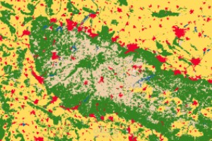
This project focuses on analyzing deforestation patterns over time using GIS and remote sensing techniques. Satellite imagery was processed, classified, and compared across multiple years to detect changes in forest cover and identify areas with significant vegetation loss.
What Was Done:
Collecting and preprocessing satellite imagery
Applying supervised/unsupervised classification
Extracting forest and non-forest classes
Conducting change detection analysis
Mapping areas of forest loss and quantifying affected regions
Creating thematic maps with clear visualization of deforestation trends
Tools Used:
ArcGIS — Remote Sensing — Raster Analysis — Classification — Change Detection
This project demonstrates my ability to use GIS and remote sensing to generate meaningful environmental insights and visualize land-cover change effectively.